 |
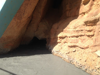
| Fallen piece of rock from the cliff hiding the river |
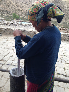 |
| local women skimming yogurt to make butter |
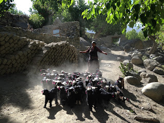 |
women taking her goats to pastureland
|
 |
| The isolate chorten |
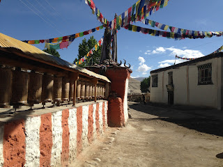 |
| Mani wall |
 |
| multi storied caves of Chosar |
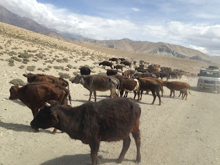 |
| The big group of local cow found here |
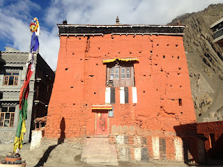 |
on of the oldest monastery from this region at Kagbeni
|
Upper
mustang trek
A short
itinerary, Information and highlights
Day 01:
Kathmandu/Pokhara by tourist bus /6 hrs /200 Km.
Day 02:
Pokhara/Jomshom by flight & trek to Kagbeni : 20
Min flight/3Hrs walk 2810M O/N @ lodge : it is the short flight early in
the morning which offers the scenic beauty of the Midland , Himalaya and TransHimalayan region . This short pleasant
flight goes through the deepest gorge in the world carved between Mt Dhaulagiri
and Mt Annapurna .and the aircraft lands at the desert and windy valley of
Jomshom .After reaching the jomshom we have to take a short acclimatization there.
We will go to the local guest house for some refreshment and a short rest over
there. Then we will meet up with the rest of the members from our trekking group.
Porters will arrange the backpack and the necessary stuff. After that we will
start our journey towards north. The trail goes through the bank of river Kali
Gandaki we are walking through the windy valley so Be prepared
to face hard breezing during the walk . The landscape is amazing around.
You have Nilgiri North behind to the south and Mt Dhaulagiri to the south west.
We will see several small settlements with apple orchards at Eklebhatti. We
will arrive our destination Kagbeni in the midday where we will have launch and
in the evening we will visit the village and monastery.
Day 03: Kagbeni /Chaile 5Hrs/3050M/On@lodge: After having the
breakfast we will leave early morning to escape the possible hard breezing during
the day. The trail goes through the bottom and ridge of the mountain following
river Kaligandaki. The trail goes through the medieval village of Tangbe where
we can see three different colors painted chorten by the side of the trail. And
the houses roofed with thatched mud and fascinating apple orchard surrounded.
Then after hour we will reach another village called chusang. This is also the
village with local style of houses, courtyard in the side and ground floor as
cow shed that makes every traveler amuse. The green terrace with apple orchard
adding the beauty of village. We will have launch here probably. Then the trails goes straight following river
valley and then we will reach the bridge where we got to see the big rock
fallen from the cliff in the middle of the river and river flowing underneath
that fallen rock. After crossing the river the trail goes upward towards chaile.
It is 15 minute walk upward to reach the village Chile.
Day 04: Chaile/Syangbochen 6Hrs/3660M/ ON@Lodge : This day the trail goes
uphill in the beginning towards northwest . We got to see newly planted apple
orchard and the trail goes upward continuously we will reach the cliff from
where we can see the village called Gyakar across the cliff. The trail
carved in the cliff looks really wondering.
Then after we will reach one pass near Samar village. We will have lunch in Samar.
Then the trail goes slightly upward and reaches another pass at 3750M. Then the
trail goes straight up to Vena where we can see few teahouses by the side of
the road. Then the trail leads further towards another pass at 3870 M From
where we can see Nilgiri on the south ,Tilicho peak, Yakawa Kang . Then the
trail goes downhill up to Syangbochen where we will stay overnight.
Day 05: Syangbochen/Ghemi 3.5 Hrs/3520M /On@lodge: The
trails goes slightly inclined upward at the beginning and reaches a pass with
beautiful chorten after a while we get to see the first sight of Geling village.
That makes you to feel that you are in the different world. The houses painted white,
red, yellow and the fenced terrace around the village and some lush green trees
looks really amazing. at this village on can feel that they are in somewhere in
the remote village of Tibet. After passing this village the trail will continue
straight towards another small settlement surrounded by green fields and lush
green trees. Then after the trail goes uphill towards the Nye pass at 3950 M
from where we can see detailed 360 panoramic view of surrounding. at the south
we can see Nilgiri , Damodar Danda , Bhirkuti Himal and towards north west we
can see Arniko Himal and the series of yellow , grey , brown , red mountain Which looks really colorful. After the pass the trail descend down to Ghami
. Ghemi is an ancient forbidden Kingdom. So there is lot of things to see in Ghemi.
After lunch we go to visit Ghemi village where we can see uniquely builded monastery,
the amazing houses, and the local people working in the field and bushy with
their livestock. At the edge of the village we can see flossing Ghami khala
coming from Arniko Himal. The color of water is amazing green even it floss
down rapidly.
Day 06: Ghemi/Tsrang / 4Hrs/3520 M/ On@Lodge: we will cross
Ghami Khola the amazing flossing green river and after we will reach the
longest Mani wall painted red and white. Far away in the distance we can see
red and Grey Mountain which looks really amazing. Then after the trail goes uphill towards
another pass. The view from the pass is really amazing .its worthy to spend
some time on the top of the Pass. Then after the trail goes down and straight. The village of Tsrang welcomes the visitor
from far distance which looks really amazing and fascinating. The fields are
really bigger then before from any place. We can see the mud wall fenced around
the field to protect the crops from livestock. And the monastery in this
village is really very nice where we can see the skeleton of the architectures hand.
And we can see one old fortress at one end of this village from where we can
see the village very well.
Day 07 : Tsrang/Lo-Manthang /4Hrs/3700M/on@Lodge : The
trails goes downhill towards the river and after crossing it goes uphill and catches
the main trail . Then the trail goes straight forward. We can see small stream
downward from the trail while walking. After walking for 2 hours we can see an
isolated chorten in the trail. then the trail goes slightly inclined uphill and reaches the
another flat grass land .on the east side at cliff we can see ancient man made
caves where the people used to live in
the ancient time to protect them from extreme cold. After crossing another pass
we can see Lo-Manthag valley which looks really beautiful. We can recognize the
royal palace from distance. We can see lots of small hills with different color
like grey, red, yellow. And the trail goes downhill towards Lo-Manthang. As we
reach the village the big gate welcomes us and we can see wall everywhere in
the village. That’s the reason this village called walled city.
Day 08: Lo-Manthag/Chosar/Lomanthag 6/7 Hrs round trip: This
day we will visit another village called Chosar which is famous for its
multistoried ancient cave, Monastery. The trail goes across the river from
where we can see perfect image of royal palace. And the trail goes through the
bank of another river passing through the fields. It takes several hours to
explore the monastery, village and caves in Chosar village.
Day 09: Lo-Manthang/Namgyal/ Lo-Manthang : 5 Hrs round trip
: The trail leads west from Lo-Manthang valley and reaches Namgyal monaster one
of the oldest and precious from this region . After visiting the monastery the
trail leads towards Tingkar village .
Day 10: Lomanthang/Dhakmar via Gharghumba /7Hrs/3820 M/6:
The trail leads upward towards the west and goes through the Dhi pass 4300M.
And the trail goes slightly downhill towards Gharghumba. We will visit
Gharghumba monastery .
Day 11: Dhakmar/Gheling
6Hrs/3570M/On@lodge: The trail leads downward from Dhakmar and reaches Ghemi
and goes uphill towards the pass and once again the trail goes downward towards
Gheling. In the evening we will visit Gheling village.
Day 12: Gheling/Kagbeni / By jeep /5Hrs drive / 2810M: We
will take jeep this day to avoid walking through same way back. The adventurous
jeep drive will take you to Kagbeni where we will be check out from restricted
area zone.
Day 13: Kagbeni/Muktinath /6Hrs /3800M/On@lodge: The trek leads
upward towards east. it is the sloppy inclined uphill and on the way we could
see many apple orchard and we will see the village called Jharkot which is
famous for its uniqueness and variety of houses build using local style. We
will visit Muktinath temple after we arrive to Muktinath. This is one of the
major pilgrim sites for both Hindus and Buddhist. We got to see many pilgrims
coming here from Lower part of Nepal and other south Asian countries. And we
can see holy eternal flame coming from the heart of the cave like structure now
its temple. 108 water spout where we got to see the devotees taking shower to wash away their sin. Also this temple is
famous for the Nun priest who takes care of the monastery and temple here.
Day 14: Muktinath/Jomshom/5Hrs/2810M/On@lodge: The trail
goes downhill and it goes uphill again through the village called Lupra . It’s
a pleasant walk with awesome panoramic view. In the evening we will have
farewell program with our team member.
Day 15: Jomshom/Pokhara by flight/20 min/810M
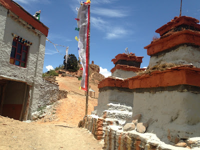 |
Chorten and entrance gate at Samar
|